Saturday, November 15, 2014

Amazing Days

Embedded image permalink

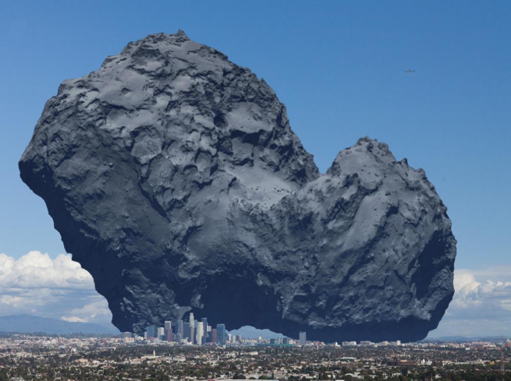
Earthlings have landed a spaceship on a comet 250,000 million miles from Earth.

Glorious feat!

This link compares the comet to the size of Los Angeles--fairly large, but a very tiny target for a spaceship to find while circling the sun.

https://twitter.com/LondonerinLA/status/533000919290765314/photo/1

Here's more information:

http://rosetta.jpl.nasa.gov/

Friday, November 7, 2014

Autumn in southern CA


We do get some fall color in southern California, at least with our liquid amber trees.  

I planted this one in about 1998.

I love watching the leaves come out in the spring, glow with green in the summer, and turn to red and gold in the autumn.

Hallelujah!

Tuesday, September 9, 2014

Great Floods

We think our highways and cities are eternal... but one great rainstorm teaches us that they are not.

web1_Cropped-Weather_090914DB_002.jpg


http://m.reviewjournal.com/news/traffic-transportation/shorter-i-15-detour-opens-passenger-vehicles

Driving I-15 from St. George, Utah, to Las Vegas and Los Angeles can be boring--except in a thunderstorm and flooding.

We did it two weeks ago, and I'm glad we didn't have to take the detour now required.

Thursday, August 14, 2014

Geology Tour

I'm pleased to see that The Watch, a weekly newspaper covering Telluride, Ouray, and Ridgway, included some of my comments on the wonderful geology tour sponsored by the Ouray County Historical Society last week.

Here's the link:

http://www.thewatchmedia.com/tour-symposium-plumb-riches-of-ourays-geology/

Red Mountain, whose color is caused by hydrothermic gas and water oxidizing iron in the debris that fell back into the caldera after the Silverton supervolcano exploded about 26 million years ago.  Nearby mountains are grey, formed from orderly layers of volcanic ash outside the caldera, which resisted intrusion of gas and water.


Thursday, August 7, 2014

Ten Surprises on the Geology Tour

Thirty lucky rock fans got the tour of a lifetime yesterday, courtesy of the Ouray County Historical Society.  
Precambrian rock 1.4 billion years old, exposed along Hwy. 550 near Ouray

Starting in Ouray, the geology tour covered faults and rock formations from Ridgway to Silverton and Coal Bank Pass.

Some participants were locals learning secrets of their mountains for the first time; others came from as far away as Denver and Los Angeles and included several geologists,

Sunny weather was the biggest surprise of the day after more than a week of heavy rains.  The 2013 tour had been pounded by rain, hampering views and keeping the group inside vehicles most of the time.

Tour leaders were geologists Larry Meckel and Robert Stoufer, both of Ouray, joined by several other local geologists. 

George Moore, a professor at Texas A & M and long-time summer resident of Ouray, planned the tour but succumbed to cancer in March.  He also designed and wrote the 117-page guide book given to each participant both last year and this year.  His wife, Glenda, accompanied the group.

A day later I’m still dazed by the sweep of geological time we witnessed on the tour, as well as the grandeur of the San Juan Mountains.  I can’t convey any of this in depth, but I can list ten surprising facts I learned.

1)  At Bear Creek Falls and other spots along Hwy. 550, there’s a 1.3 billion year gap between one rock layer and the next.  The Precambrian rock there is roughly 1.4 billion years old, and on top of it lies the San Juan Tuff, only 27 million years old.  Because the Uncompahgre River cuts through the ancient rock, it’s known as the Uncompahgre Formation.

2)  There were 15 stratovolcanoes in the San Juan area between 33 and 23 million years ago, and they erupted with pyroclastic debris flows extending to New Mexico, central Colorado, and near the Utah border.

3)   Telluride is on the eastern edge of the Paradox Basin, geologically speaking.  When the Uncompahgre Plateau rose up during the late Paleozoic era, the basin to its west went down.  Red and white rocks of Paleo- and Mesozoic eras were deposited in it.

4)  The Telluride Conglomerate is hard to follow from place to place because it was deposited by a system of river channels flowing out of mountains to the east.  Rocks from the Grenadier Mountains are among the many pebbles and large rocks found in it.

5)  The whole erosional surface that extended over much of Colorado about 50 million years ago is sometimes called the Telluride Unconformity—also the Eocene Unconformity and the Great Unconformity.  Volcanic rocks were laid down on it, and then glaciers arrived.

6)   There are sea shell fossils on Molas Pass near Andrews Lake in the Leadville Limestone formation from the Mississippian era, 350 million years ago.

7)  The Ridgway Fault runs east-west along the foot of Log Hill and marks the southern end of the Uncompahgre uplift, known locally as Dallas Divide.  “Uncompahgria” was one of two island ranges of the ancestral Rockies. 

8)  Red Mountain is part of the debris that fell back into the 10-mile-wide hole made when the Silverton supervolcano erupted about 27.6 million years ago.  It’s red because later hydrothermal pressures were able to intrude the crushed rock with minerals that weathered to iron oxides.  Layers of volcanic rock outside the caldera resisted this intrusion.

9)  Over 30 geologists in the area meet regularly in Ouray to study and discuss these things.

Ouray, Colorado
10)  The geology tour cost $125, a small price geologically speaking.  It covered 1.6 billion years for less than 8 cents per million years.  
There will be another major geology gathering on September 5-8.  Friends of Mineralogy of Colorado will host the Ouray-Silverton San Juan Mountains Minerals Symposium with speakers and field trips.  http://friendsofmineralogycolorado.org/index.php/events/13-meetings/39-ouray-silverton-san-juan-mountains-mineral-symposium2


Monday, March 31, 2014

Pelicans at Work

Pelicans in a feeding frenzy at sunset
Pelicans repeatedly torpedo into water

Something in that water is attracting them.
Usually they just fly in straight lines...

Sunday, March 30, 2014

When hills skip...

Nothing makes you shout "Hallelujah!" like an earthquake...
Westwood with downtown LA and Puente Hills in distance

http://www.latimes.com/local/la-me-0330-quake-puentehills-20140330,0,3860867.story#axzz2xVausnqP

We are comparing notes after the 5.1 south of Los Angeles, and thinking about trying to get the cracked chimney pulled down and replaced with a steel pipe before nature pulls it down for us.

The mountains melt like wax before YHWH,
before the ruler of all the earth.
    ~ Psalm 97:5

The mountains skipped like rams,
The hills like lambs.
  ~ Psalm 114:6

Moving graphic to demonstrate P-waves and S-waves:

http://www.geo.mtu.edu/UPSeis/waves.html

First-hand accounts:

http://www.latimes.com/local/lanow/la-me-ln-quake-20140329%2c0%2c7936610.story#axzz2xVausnqP

A friend was in the Disney Concert Hall in the second balcony, where it really shook.  The orchestra played on as some in the audience got up and left.  It wasn't until an aftershock that my friend decided she'd had enough and left the building.

Thursday, March 27, 2014

Duet at Dawn

Venus and the moon
both shining in the southeast sky
before dawn today

(in the south Saturn
facing Scorpio
and farther west Mars
hanging in Virgo
just above Spica)

half of our solar system on display
held in the ecliptic plane
as Earth marks the vernal equinox

Friday, March 14, 2014

Suspended

Between a moon
March 14, 2014

and a star
suspended 
at sunset
facing Orion
and asking
all the big questions

Sunday, February 16, 2014

Visiting the Anazasis

Check out the dazzling photos by David Kelly in today's travel section of the LA Times.

http://www.latimes.com/travel/california/la-tr-anasazi-cedar-mesa-utah-20140216-photos,0,4616271.photogallery#axzz2tWafhYvW

Kelly's report on the Anazasi treasures of Cedar Mesa tells me what I missed when I drove Hwy. 261 through there last summer.  

https://picasaweb.google.com/102150538747404124091/UtahHwy261

I thought that over-the-cliff highway from Utah 95 to Mexican Hat was the main attraction, but now
Can you find the four switchbacks in this photo?
I will go back to explore the canyons of Cedar Mesa and look at the ruins.  Apparently those marked on the map of Natural Bridges National Monument are just the beginning.


Mountains, volcanoes, cliffs and layers of colored rock always delight me--what a thrill to envision continents being formed, sediment being laid down, raised, and eroded.

But when you add the human dimension--ancient people beholding these views, building homes, growing corn and beans, painting on rock--you feel the mystery of human life on this planet.